Rx Blog
The GNSS Medium and its Message

Marshall McLuhan is a Canadian Philosopher and author of the now famous quote “The medium is the message”.
The point he makes is that with technology being an extension of human functions it has societal impacts that shape the way we interact with the world. We need to watch for this!
Admittedly, having a predominantly technological background it was at first quite difficult for me to grasp this. In the literal sense, a medium carries a message. I was first introduced to this quote when I was studying 4th year engineering. I stared deeply into my Walkman, searching for the message that was the cassette tape. The only message I received then was that a slowdown in playback meant I needed to replace the batteries, or to hit stop immediately after noticing garbled audio because the chromium dioxide tape had become entangled with the strip roller and magnetic head.
Within a few short years I came to realize that the message McLuhan suggested was contained in the cassette tape was portability. Similarly, the CD’s message was digitization. The MP3’s message was distribution. Prior to the cassette, replay was the message in vinyl…opposed to live performance. I think we are yet to see the true message of streaming music services like Spotify, but I am placing one of my bets on it being Artificial Intelligence.
What about positioning and location technology? From a societal perspective, what can we infer is the message Marshall McLuhan would have us observe?
The GNSS receiver itself is an extension of our innate navigation abilities. We have evolved from being within visual range of a landmark and deriving a heading from a clear night sky, to using a receiver ranging to multiple satellites broadcasting their location, at any time and through any weather, and being able to compute an accurate latitude, longitude and height. The message of the receiver is a coordinate location on the planet.
With a coordinate system, and the development of DGNSS and RTK corrections techniques, precision enters the conversation, adding more digits after the decimal in a location coordinate. Many might say that the message of DGNSS and RTK is clearly accuracy, but what would McLuan say?
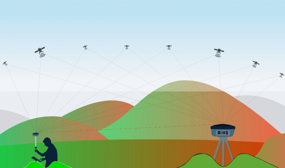
It’s possible to see that message as interconnection. In both corrections and techniques, the rover receiver is comparing its measurements to the satellites with the base station’s measurements. Since a base station has a better view of the sky, it is considered the reference to generate measurement corrections from. Those corrections are applied to the rover’s measurements to common satellites with the base station generating a differentially corrected position. Connecting the base-rover pair was a radio modem to transfer those corrections from the base to the rover.
In the data sheet of any commercially available GNSS receiver / chipset there is an accuracy listed for Single Point, DGNSS and RTK, where the latter two show much better accuracies than single point. Deeper in the manual you can find instructions for connecting to another receiver for corrections. Considering Assisted GNSS, the receiver needs to connect to a server to download and store predicted ephemeris for the next fast powerup.
Historically, position output from a receiver was always best when connected to an A-GNSS server and corrections network. Now, telecommunications infrastructure has enough coverage and bandwidth with good economics to support multiple GNSS constellations and contemporary corrections techniques like PPP and PPP-RTK.
The interaction between a GNSS receiver and its integrated device has become symbiotic. A GNSS receiver needs a connection to a GNSS data service for a good position and the device itself needs an accurate position to attach to its purpose. Separately, they might not reach their full value potential. They need each other. This is commonly seen in IoT devices integrating GNSS technologies with growing accuracy requirements. This brings us to the next message, which I propose is spatial context.
Coordinates are simply a set of numbers representing a point in space and time. That coordinate aligns with other descriptions and telematics of that point for a fuller picture of what is happening. With additional points connected in the same way we can derive a situational overview in realtime and take informed actions.
Take for instance the decision to purchase a meal from a restaurant visited for the first time. With a few taps on a smartphone a pin appears on a map relative to your position, complete with links to ratings and reviews. A menu and pricing can be accessed, busy times, reservation and sharing options, even recommended modes of transportation to get to the restaurant. You could even access the street view to see what the entrance of the restaurant looks like to determine if you should drive or walk. Today, we have full spatial context. Accuracy in positioning becomes essential.
Back in the day, most of us would have given up the search after discovering the page listing the restaurant address and phone number had been torn out of the phone book. Only the truly committed would search out another phone booth with an undamaged directory, only to then search the address on a spiral bound city street map that was likely out of date. Choosing the restaurant by name alone was certainly a gamble. Almost as risky as trusting a brand new cassette in a hungry Walkman.
Before I type anything more that might give away my age, I’ll end this post with another of McLuhan’s profound quotes: “We shape our tools and thereafter the tools shape us.”
Touché